Berkas:United Kingdom United States Locator.svg

Ukuran pratayang PNG ini dari berkas SVG ini: 800 × 353 piksel Resolusi lainnya: 320 × 141 piksel | 640 × 283 piksel | 1.024 × 452 piksel | 1.280 × 565 piksel | 2.560 × 1.130 piksel | 940 × 415 piksel.
Ukuran asli (Berkas SVG, secara nominal 940 × 415 piksel, besar berkas: 2,56 MB)
Ringkasan
| Deskripsi |
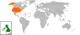
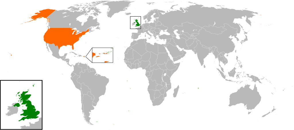
English: Map of the world showing the location of the United Kingdom and the United States of America. |
| Tanggal | |
| Sumber | Karya sendiri |
| Pembuat | Jolly Janner |
Lisensi
| Saya, pemegang hak cipta karya ini, merilis karya ini ke domain umum. Lisensi ini berlaku di seluruh dunia. Di sejumlah negara, tindakan ini tidak memungkinkan secara sah; bila seperti itu: Saya memberikan siapa pun hak untuk menggunakan karya ini untuk tujuan apa pun, tanpa persyaratan apa pun, kecuali yang ditetapkan oleh hukum. |
Riwayat berkas
Klik pada tanggal/waktu untuk melihat berkas ini pada saat tersebut.
| Tanggal/Waktu | Miniatur | Dimensi | Pengguna | Komentar | |
|---|---|---|---|---|---|
| terkini | 20 Maret 2017 16.00 | | 940 × 415 (2,56 MB) | RaviC | add dependencies, inset map for Virgin Islands region where both states share a maritime border |
| 24 Desember 2016 02.43 |  | 940 × 415 (1,79 MB) | BurritoBazooka | put all Faroe islands except Suðuroy region behind black border of UK box. Make two boxes (transparent group rectangle and white bg rectangle) same stroke thickness. | |
| 24 Desember 2016 00.43 |  | 940 × 415 (1,79 MB) | BurritoBazooka | add France and Faroe Islands to UK box by re-cutting it from its place on the map (b/c why should ROI, another sovereign state, be shown, and not France and the Faroe Islands?) Also the box has its own group now. | |
| 24 Desember 2016 00.34 |  | 940 × 415 (1,78 MB) | BurritoBazooka | French Polynesia, Pitcairn Islands were showing in the UK box, but these are not in the same area as the British Isles at all. Also, are Falklands etc not on the same level as Puerto Rico? | |
| 7 Desember 2016 18.38 |  | 940 × 415 (1,78 MB) | Mikey641 | Accident | |
| 7 Desember 2016 18.38 |  | 512 × 226 (753 KB) | Mikey641 | -- | |
| 3 Maret 2013 18.09 |  | 940 × 415 (1,78 MB) | Timothy Gu | +South Sudan (w/ small Britain map) | |
| 2 Maret 2012 21.25 |  | 940 × 415 (1,63 MB) | Jrobin08 | Reverted to version as of 20:37, 24 June 2009 (Easier to see the United Kingdom. Maybe someone can add South Sudan to the map, but keep the UK zoom box in.) | |
| 23 September 2011 21.05 |  | 940 × 415 (1,76 MB) | Bazonka2 | + South Sudan | |
| 24 Juni 2009 20.37 |  | 940 × 415 (1,63 MB) | Jolly Janner | {{Information |Description={{en|1=Map of the world showing the location of the United Kingdom and the United States of America.}} |Source=Own work by uploader |Author=Jolly Janner |Date=2009-0 |
Penggunaan berkas
Halaman berikut menggunakan berkas ini:
Penggunaan berkas global
Wiki lain berikut menggunakan berkas ini:
- Penggunaan pada ar.wikipedia.org
- Penggunaan pada ca.wikipedia.org
- Penggunaan pada de.wikipedia.org
- Penggunaan pada en.wikipedia.org
- Penggunaan pada es.wikipedia.org
- Penggunaan pada fr.wikipedia.org
- Penggunaan pada he.wikipedia.org
- Penggunaan pada hy.wikipedia.org
- Penggunaan pada it.wikipedia.org
- Penggunaan pada ja.wikipedia.org
- Penggunaan pada ps.wikipedia.org
- Penggunaan pada pt.wikipedia.org
- Penggunaan pada ru.wikipedia.org
- Penggunaan pada th.wikipedia.org
- Penggunaan pada tr.wikipedia.org
- Penggunaan pada uk.wikipedia.org
- Penggunaan pada www.wikidata.org
- Penggunaan pada zh.wikipedia.org