Berkas:Timberlake-map-tanasi-1765.jpg
Tak tersedia resolusi yang lebih tinggi.
Timberlake-map-tanasi-1765.jpg (434 × 286 piksel, ukuran berkas: 44 KB, tipe MIME: image/jpeg)
Ringkasan
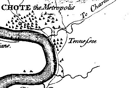
| Deskripsi | Detail of Henry Timberlake's 1762 (published 1765) "Draught of the Cherokee Country" showing Tanasi. Timberlake's spelling of Tanasi as "Tennessee" is one of the first widely published uses of this spelling of the state's namesake. Tanasi declined after 1730 and by Timberlake's time had been overshadowed by neighboring Chota. The bend in the river is Bacon's Bend. |
| Tanggal | |
| Sumber | Henry Timberlake, Memoirs (1765) |
| Pembuat | Henry Timberlake |
| Versi lainnya |
|

Lisensi
|
This work is in the public domain in its country of origin and other countries and areas where the copyright term is the author's life plus 100 years or fewer. | |
| Berkas ini telah diidentifikasi bebas dari pembatasan menurut hukum hak cipta termasuk semua hak terkait dan relevan. | |
Riwayat berkas
Klik pada tanggal/waktu untuk melihat berkas ini pada saat tersebut.
| Tanggal/Waktu | Miniatur | Dimensi | Pengguna | Komentar | |
|---|---|---|---|---|---|
| terkini | 27 Maret 2008 22.09 | | 434 × 286 (44 KB) | BrineStans | {{Information |Description=Detail of Henry Timberlake's 1762 (published 1765) "Draught of the Cherokee Country" showing Tanasi. Timberlake's spelling of Tanasi as "Tennessee" is one of the first widely published uses of this spelling of the state's names |
Penggunaan berkas
Halaman berikut menggunakan berkas ini:
Penggunaan berkas global
Wiki lain berikut menggunakan berkas ini:
- Penggunaan pada arz.wikipedia.org
- Penggunaan pada da.wikipedia.org
- Penggunaan pada en.wikipedia.org
- Penggunaan pada pl.wikipedia.org
- Penggunaan pada vi.wikipedia.org