Berkas:Significant tornado alley.gif
Tak tersedia resolusi yang lebih tinggi.
Significant_tornado_alley.gif (512 × 360 piksel, ukuran berkas: 8 KB, tipe MIME: image/gif)
Ringkasan
| Deskripsi |
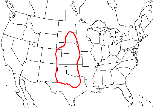
English: A map of the united states with Tornado Alley outlined, here defined as the area where approximately 1 day or greater per decade was near (25 mi; 40 km) a significant (F2 or stronger) tornado. |
| Sumber | http://www.nssl.noaa.gov/hazard/svrwxmisc.html http://www.nssl.noaa.gov/hazard/img/sigtoralley.gif |
| Pembuat | NSSL |
Lisensi
This image is in the public domain because it contains materials that originally came from the U.S. National Oceanic and Atmospheric Administration, taken or made as part of an employee's official duties.
|
- The NOAA emblem is the property of the U.S. Government and a trademark of the United States Department of Commerce.
Riwayat berkas
Klik pada tanggal/waktu untuk melihat berkas ini pada saat tersebut.
| Tanggal/Waktu | Miniatur | Dimensi | Pengguna | Komentar | |
|---|---|---|---|---|---|
| terkini | 20 Oktober 2006 07.23 | | 512 × 360 (8 KB) | Runningonbrains | {{Information |Description=A map of the united states with Tornado Alley outlined, here defined as the area where approximately 1 day or greater per decade contained a significant tornado. |Source=http://www.nssl.noaa.gov |
Penggunaan berkas
Tidak ada halaman yang menggunakan berkas ini.
Penggunaan berkas global
Wiki lain berikut menggunakan berkas ini:
- Penggunaan pada de.wikipedia.org
- Penggunaan pada en.wikipedia.org
- Penggunaan pada fi.wikipedia.org
- Penggunaan pada fr.wikipedia.org
- Penggunaan pada gl.wikipedia.org
- Penggunaan pada it.wikipedia.org
- Penggunaan pada lt.wikipedia.org
- Penggunaan pada pt.wikipedia.org
- Penggunaan pada ru.wikipedia.org
- Penggunaan pada simple.wikipedia.org
- Penggunaan pada uk.wikipedia.org