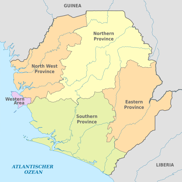
Berkas:Sierra Leone, administrative divisions - de - colored 2018.svg

Ukuran asli (Berkas SVG, secara nominal 1.606 × 1.606 piksel, besar berkas: 220 KB)
Ringkasan


.svg)


_(Paris_zoom).svg)
.svg)
,_administrative_divisions_-_de_-_colored_(multizoom).svg)
_-_colored.svg)
.svg)
,_administrative_divisions_-_Nmbrs_(multizoom).svg)
,_administrative_divisions_-_de_-_colored.svg)
_-_de_-_colored.svg)

.svg)

.svg)

|
This map has been made or improved in the German Kartenwerkstatt (Map Lab). You can propose maps to improve as well.
|
Lisensi
Usage of this file with:

explanatory notes: Legally binding is only the full legalcode. For a free usage I recommend to respect the following licence conditions:
1. Provide my name as given above: NordNordWest,
2. a copy of, or the URI for, the applicable license: https://creativecommons.org/licenses/by-sa/3.0/de/legalcode,
3. the title of the work,
4. in the case of an adaptation, a credit identifying the use of the work in the adaptation.
This license and the rights granted hereunder will terminate automatically upon any breach by you of the terms of this license. Any of the above conditions can be waived if you get permission from the copyright holder. If you have questions or wish differing conditions, please contact me through nnwest or my discussion page ![]() t-online.de
t-online.de
- Anda diizinkan:
- untuk berbagi – untuk menyalin, mendistribusikan dan memindahkan karya ini
- untuk menggubah – untuk mengadaptasi karya ini
- Berdasarkan ketentuan berikut:
- atribusi – Anda harus mencantumkan atribusi yang sesuai, memberikan pranala ke lisensi, dan memberi tahu bila ada perubahan. Anda dapat melakukannya melalui cara yang Anda inginkan, namun tidak menyatakan bahwa pemberi lisensi mendukung Anda atau penggunaan Anda.
- berbagi serupa – Apabila Anda menggubah, mengubah, atau membuat turunan dari materi ini, Anda harus menyebarluaskan kontribusi Anda di bawah lisensi yang sama seperti lisensi pada materi asli.

Riwayat berkas
Klik pada tanggal/waktu untuk melihat berkas ini pada saat tersebut.
| Tanggal/Waktu | Miniatur | Dimensi | Pengguna | Komentar | |
|---|---|---|---|---|---|
| terkini | 19 Januari 2018 15.40 | | 1.606 × 1.606 (220 KB) | NordNordWest | == {{int:filedesc}} == {{Information |description= {{de|Karte der politischen Gliederung von Sierra Leone, 2018}} {{en|Map of administrative divisions of Sierra Leone, 2018}} |source={{Own using}} {{f|Saarland location map.svg}} by {{U|Lantus}} |date={... |
Penggunaan berkas
2 halaman berikut menggunakan berkas ini:
Penggunaan berkas global
Wiki lain berikut menggunakan berkas ini:
- Penggunaan pada ab.wikipedia.org
- Penggunaan pada ar.wikipedia.org
- Penggunaan pada ca.wikipedia.org
- Penggunaan pada de.wikipedia.org
- Penggunaan pada en.wikipedia.org
- Penggunaan pada es.wikipedia.org
- Penggunaan pada frr.wikipedia.org
- Penggunaan pada he.wikipedia.org
- Penggunaan pada hr.wikipedia.org
- Penggunaan pada hu.wiktionary.org
- Penggunaan pada it.wikipedia.org
- Penggunaan pada ja.wikipedia.org
- Penggunaan pada lt.wikipedia.org
- Penggunaan pada mdf.wikipedia.org
- Penggunaan pada mt.wikipedia.org
- Penggunaan pada nl.wikipedia.org
- Penggunaan pada no.wikipedia.org
- Penggunaan pada pt.wikipedia.org
- Penggunaan pada ro.wikipedia.org
- Penggunaan pada sv.wikipedia.org
- Penggunaan pada tr.wikipedia.org
- Penggunaan pada zh.wikipedia.org