Berkas:Map of Alameda County 1878 LARGE.jpg

Ukuran pratayang ini: 800 × 509 piksel. Resolusi lainnya: 320 × 204 piksel | 640 × 407 piksel | 960 × 611 piksel.
Ukuran asli (960 × 611 piksel, ukuran berkas: 496 KB, tipe MIME: image/jpeg)
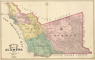
Taken from en:
|
This work is in the public domain in its country of origin and other countries and areas where the copyright term is the author's life plus 70 years or fewer. | |
| Berkas ini telah diidentifikasi bebas dari pembatasan menurut hukum hak cipta termasuk semua hak terkait dan relevan. | |
Author: Haynes, M.B.; Thompson & West Date: 1878 Short Title: Alameda County map Publisher: Oakland, Thompson and West Type: Atlas Map Scale:1: 126,720
Source: http://www.alamedainfo.com/alameda_1878.htm
Riwayat berkas
Klik pada tanggal/waktu untuk melihat berkas ini pada saat tersebut.
| Tanggal/Waktu | Miniatur | Dimensi | Pengguna | Komentar | |
|---|---|---|---|---|---|
| terkini | 12 Juli 2005 15.42 | | 960 × 611 (496 KB) | Pyramide~commonswiki | Taken from en: {{pd}} '''Author:''' Haynes, M.B.; Thompson & West '''Date:''' 1878 '''Short Title:''' Alameda County map '''Publisher:''' Oakland, Thompson and West '''Type:''' Atlas Map '''Scale:'''1: 126,720 Source: http://www.alamedainfo.com/alameda_ |
Penggunaan berkas
Halaman berikut menggunakan berkas ini:
Penggunaan berkas global
Wiki lain berikut menggunakan berkas ini:
- Penggunaan pada en.wikipedia.org
- Penggunaan pada fi.wikipedia.org
- Penggunaan pada fr.wikipedia.org
- Penggunaan pada hu.wikipedia.org
- Penggunaan pada no.wikipedia.org
- Penggunaan pada pam.wikipedia.org
- Penggunaan pada ru.wikipedia.org