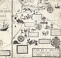
Berkas:Desceliers 1550 map - Australia detail.jpg

Ukuran asli (2.711 × 2.589 piksel, ukuran berkas: 1,1 MB, tipe MIME: image/jpeg)

Berkas ini berasal dari Wikimedia Commons dan mungkin digunakan oleh proyek-proyek lain. Deskripsi dari halaman deskripsinya ditunjukkan di bawah ini.

Deskripsi This is a detail from a 1550 world map by Pierre Desceliers, from the location where Australia would be, and purportedly showing Australian features. It is one of the Dieppe maps, which are commonly put forward as evidence for the theory that the Portuguese discovered Australia in the 16th century.
Tanggal
Sumber This is a cropped and colour-balanced scan of an 1898 facsimile of this detail, taken from the British Museum's copy of the original map. Access to it is available on the National Library of Australia's website, at http://nla.gov.au/nla.map-rm2057-5. The graphical user interface provided does not support downloading the full image at full resolution, but the back end can be cajoled to do so by manually editing the CGI arguments in the URL.
Pembuat
Pierre Desceliers  (1487–1553)  wikidata:Q44053
 
Pierre Desceliers
Nama alternatif
Pierre Descalier
Deskripsi French kartografer dan imam Katolik
Tanggal kelahiran/kematian 1487 Sunting ini di Wikidata after 1553
date QS:P,+1553-00-00T00:00:00Z/7,P1319,+1553-00-00T00:00:00Z/9
/ 1553 Sunting ini di Wikidata
Tempat kelahiran Arques-la-Bataille Sunting ini di Wikidata
Periode pengerjaan 1537 - 1553
date QS:P,+1550-00-00T00:00:00Z/7,P580,+1537-00-00T00:00:00Z/9,P582,+1553-00-00T00:00:00Z/9
 Sunting ini di Wikidata
Tempat pengerjaan
Pengawasan otoritas
creator QS:P170,Q44053
Izin
(Menggunakan kembali berkas ini)
Ini adalah suatu perbanyakan fotografis dari sebuah karya seni dua dimensi. Karya seni tersebut berada pada domain publik karena alasan berikut:
Public domain

This work is in the public domain in its country of origin and other countries and areas where the copyright term is the author's life plus 100 years or fewer.


You must also include a United States public domain tag to indicate why this work is in the public domain in the United States.
Berkas ini telah diidentifikasi bebas dari pembatasan menurut hukum hak cipta termasuk semua hak terkait dan relevan.
Posisi resmi Wikimedia Foundation adalah bahwa "faithful reproductions of two-dimensional public domain works of art are public domain, and that claims to the contrary represent an assault on the very concept of a public domain". Untuk detilnya, lihat Commons:When to use the PD-Art tag.
Oleh karena itu, perbanyakan fotografis ini juga dianggap berada pada domain publik. Mohon diperhatikan bahwa hukum lokal mungkin saja melarang atau membatasi penggunaan kembali berkas ini di wilayah hukum anda. Lihat Commons:Reuse of PD-Art photographs.

Riwayat berkas

Klik pada tanggal/waktu untuk melihat berkas ini pada saat tersebut.

Tanggal/WaktuMiniaturDimensiPenggunaKomentar
terkini2 Mei 2008 01.03Miniatur versi sejak 2 Mei 2008 01.032.711 × 2.589 (1,1 MB)Hesperiancolour balanced
20 Februari 2008 12.34Miniatur versi sejak 20 Februari 2008 12.342.711 × 2.589 (920 KB)Hesperianmuch higher resolution
28 Desember 2007 12.18Miniatur versi sejak 28 Desember 2007 12.18732 × 696 (191 KB)Hesperian{{Information |Description=This is a detail from a 1550 world map by Pierre Desceliers, from the location where Australia would be, and purportedly showing Australian features. It is one of the Dieppe maps, which are commonly put forward as eviden

Halaman berikut menggunakan berkas ini:

Penggunaan berkas global

Wiki lain berikut menggunakan berkas ini:

Metadata