Aurora, Colorado
kota di Amerika Serikat
Aurora adalah kota terpadat yang ketiga di negara bagian Colorado, Amerika Serikat. Kota ini terletak di Arapahoe, Adams dan Douglas county. Kota ini juga kota ke 58 terpadat di Amerika Serikat.
City of Aurora | |
|---|---|
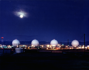
 Pandangan Buckley Air Force Base | |
| Julukan: The Gateway to the Rockies | |
 Location in Arapahoe County and the State of Colorado | |
| Negara | |
| Negara Bagian | |
| County | Arapahoe County[1] Adams County Douglas County |
| Platted | 1891 as Fletcher |
| Incorporated (town) | 1903-05-05, as the Town of Fletcher[2] |
| Incorporated (city) | 1929 as the City of Aurora[3] |
| Pemerintahan | |
| • Jenis | Home Rule Municipality[1] |
| • Mayor | Ed Tauer (R) |
| Luas | |
| • Total | 142,7 sq mi (369,7 km2) |
| • Luas daratan | 142,5 sq mi (369,1 km2) |
| • Luas perairan | 0,2 sq mi (0,2 km2) |
| Ketinggian | 5.471 ft (1.648 m) |
| Populasi (2008)[4] | |
| • Total | 319.057 |
| • Kepadatan | 1.939,6/sq mi (789/km2) |
| Zona waktu | UTC-7 (MST) |
| • Musim panas (DST) | UTC-6 (MDT) |
| ZIP codes | |
| Kode area telepon | Both 303 and 720 |
| GNIS feature ID | 0204737 |
| Highways | I-70, I-225, US 40, SH 30, SH 83, SH 88, E-470 |
| Situs web | City of Aurora |
Kota Kembar
suntingKota kembar adalah:
Referensi
sunting- ^ a b "Active Colorado Municipalities". State of Colorado, Department of Local Affairs. 2007-02-27. Diarsipkan dari versi asli tanggal 2010-11-23. Diakses tanggal 2007-02-27.
- ^ "Colorado Municipal Incorporations". State of Colorado, Department of Personnel & Administration, Colorado State Archives. 2004-12-01. Diakses tanggal 2007-08-18.
- ^ "Aurora History". City of Aurora, Colorado. Diakses tanggal 2007-08-23.
- ^ "Annual Estimates of the Population for All Incorporated Places in Colorado" (CSV). 2000-2008 Population Estimates. U.S. Census Bureau, Population Division. Diakses tanggal 2009-12-23.
- ^ "ZIP Code Lookup" (JavaScript/HTML). United States Postal Service. August 19, 2007. Diakses tanggal August 19, 2007.
Pranala luar
sunting